
GNSS-denied navigation for unmanned surface vessels
Navigation kits for unmanned surface vessels that lose GNSS to a blocked sky, jamming or spoofing: three configurations, one standard navigation feed.
Three navigation kits for unmanned surface vessels, each built for a different GNSS failure. GB-1 bridges short outages under bridges and beside structures. JR-4 and JR-7 are built for boats working where GNSS is deliberately jammed: JR-4 for hulls of about 2.5–5 m, JR-7 for hulls of about 7.5 m and up. Each kit fuses its sensors in an inertial unit and gives your autopilot one standard navigation feed. You keep your hull and your autopilot.
Configurations
| GB-1 gap bridging | JR-4 jamming resilience | JR-7 jamming resilience | |
|---|---|---|---|
| For | Bridges, culverts, quays, structures: outages of seconds to minutes; any displacement hull | Jamming regions; hulls of about 2.5–5 m | Jamming regions; hulls of about 7.5 m and up |
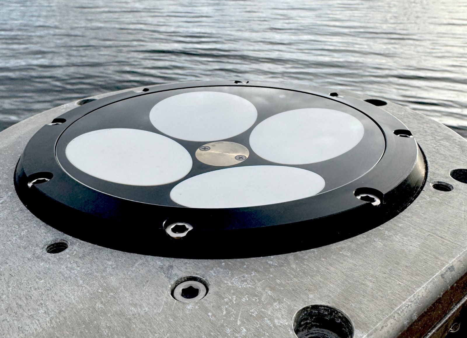
| GNSS antenna | Dual survey antennas¹ | 4-element CRPA² | 7-element CRPA² |
| Inertial unit | Tactical-grade MEMS | Compact fibre-optic-gyro (FOG) gyrocompass | FOG gyrocompass, higher grade |
| DVL³ | Water Linked DVL A125, to 125 m | Water Linked DVL A125 Performance, to 125 m | Nortek DVL 333 Surface (controlled variant), to 300 m |
| Heading⁴ | 0.03° with GNSS, on an antenna baseline over 2 m | 0.15° × sec(latitude) | 0.025° × sec(latitude) |
| Drift, no DVL | About 3 m after 30 s¹ | 9 m after 2 min | 3.15 m after 2 min |
| Drift with DVL⁵ | About 1 % of distance | 0.20 % of distance | 0.05 % of distance |
| Integrity monitoring | Option | Included | Included |
| Weight / power⁶ | 1.35 kg / 10 W | 4.49 kg / 24.7 W | 19.8 kg / 57 W |
| Export | Confirmed per destination | Subject to export licensing | Subject to export licensing |
Figures for each unit; DVL figures are the DVL makers’ datasheet figures. Drift figures are CEP50 where stated.
- Filtered anti-jam antennas are an option: they reject weak interference from near the horizon, and they also weaken satellites low in the sky. The dual-antenna RTK receiver sits inside the inertial unit, with raw data logged for PPK. The inertial unit’s figures are our series figures: gyro bias under 0.5°/h, and the 30 s drift is at sea with RTK before the outage.
- With null-steering. JR-4 nulls one interference source per band (null depth 20–40 dB) on GPS L1/L2, Galileo E1/E5b, GLONASS G2/G3 and BeiDou B1/B2b. JR-7 nulls up to 6 sources (40 dB typical suppression) on GPS L1/L2, Galileo E1, QZSS and SBAS. Neither protects L5 or E5a. Both pair with a multi-band receiver with anti-jam firmware (interference mitigation and monitoring).
- Bottom-lock ranges depend on the seabed. Velocity: ±1 % or worse (A125), ±0.1 % (A125 Performance), ±0.3 % (DVL 333 Surface, through the hull or on a pole).
- Antenna baseline over 2 m; no figure for shorter baselines. Through a short gap the gyros hold heading. JR headings are with GNSS or DVL.
- For outages of up to 5 minutes, at sea: a figure for a MEMS inertial unit with DVL aiding, not the GB-1 unit’s own figure. JR figures are for a straight line.
- Sum of the units, without cables, mounts or enclosures. GB-1’s 1.35 kg excludes the survey antennas; 1.84 kg with two filtered antennas. JR-4’s inertial unit sits in a dry enclosure. JR-7: plus the DVL’s sea valve and bell housing if fitted through the hull.
Choosing a configuration
- GB-1 for a blocked sky: under bridges, in culverts, beside wind-turbine foundations in shallow water and along quays. Nothing is jamming the signal there, so an anti-jam antenna doesn’t help. GB-1 carries the position on the inertial unit and the DVL, and with the feed integrated (integration available) the autopilot can keep steering and hold the line. The survey-grade record still comes from post-processing.
- JR-4 or JR-7 where jamming is documented: the Baltic, the Black Sea, the Eastern Mediterranean, the Red Sea and the Gulf. IMCA Information Note 1730 lists these areas as ones with routine GNSS interference. The CRPA is designed to keep GNSS usable; the inertial unit and the DVL bridge the minutes when it cannot. Choose by hull size.
- Only the RTK correction link drops: that is not GNSS denial. A PPP correction service (2 cm RMS to 2.5 cm 95 % horizontal, once converged) and raw data logged for PPK are the cheaper answer, and GB-1 sets up both.
GNSS integrity monitoring
GNSS integrity monitoring is designed to catch a spoofed fix, the hardest failure to see because the position looks normal. It is designed to check GNSS against the receiver’s interference flags, Galileo navigation-message authentication (OSNMA) where the configured receiver supports it, and the inertial and DVL track, and to drop GNSS from the solution when they disagree, always alerting the operator. It is included in JR-4 and JR-7 and is an option on GB-1. Integration is available; it is configured for each boat.
Navigation output
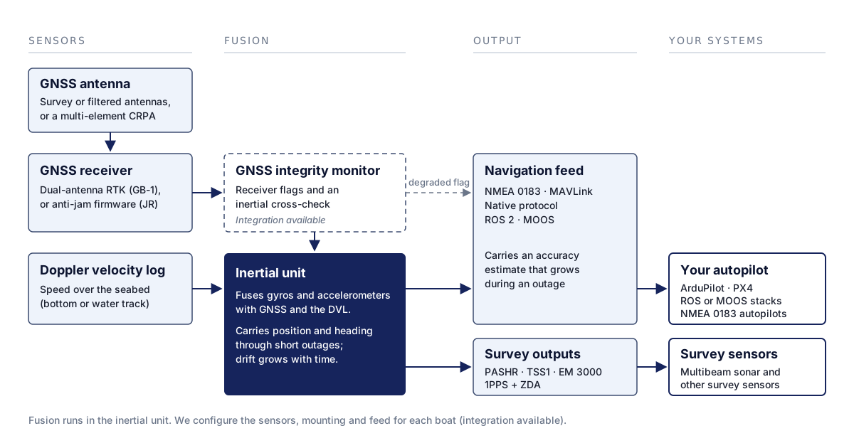
Each kit’s inertial unit fuses the sensors and gives your autopilot one standard navigation feed. The feed carries
an accuracy estimate that grows during an outage. ArduPilot takes it in MAVLink GPS_INPUT, and other
autopilots take it over NMEA 0183, so with integration the autopilot can tell dead reckoning from a GNSS fix
(integration available).
Integration is available for ArduPilot, PX4, ROS- and MOOS-based stacks, and autopilots that take NMEA 0183. The full interface and message list is part of the specification, on request.
Limitations
- A DVL needs the seabed within range to lock onto it. In deeper water it tracks the water, and the current then sets the drift: 0.1 m/s of current is about 360 m an hour.
- A DVL is not for planing hulls. Aerated water under a planing hull makes it lose lock, and the A125 measures to 9 m/s (about 17 kt).
- Neither CRPA protects L5 or E5a.
- Not for sand-bed rivers, fully enclosed water or high-latitude scintillation. A moving sand bed biases the DVL; tunnels and the space under wharf decks are work for a robotic total station or SLAM; and no antenna fixes ionospheric scintillation.
- Integrity monitoring isolates a bad fix; it does not restore GNSS. A spoof that stays within the inertial solution’s uncertainty cannot be detected.
- Performance depends on the boat. It depends on the hull, the sensor mounting and the lever arms, and we configure those for each boat.
Integration and support
| Integration | We fit the sensors, measure the lever arms, configure the inertial unit and set up the feed for your autopilot (integration available). |
| Delivery | Commissioning on your water, operator training, and support from our UK and EU teams. |
| Ordering | Configured to order, quoted per boat. |
Questions and answers
What is GNSS-denied navigation on an unmanned surface vessel?
It is navigation built for an unmanned surface vessel that loses its satellite fix to a blocked sky, jamming or spoofing. An inertial unit and a Doppler velocity log carry the position through the gap; how long the position holds depends on the configuration (see the configurations table).
Do I need an anti-jam antenna to survey under bridges?
No. Under a bridge the sky is blocked; nothing is jamming the signal. GB-1’s inertial unit and DVL carry the boat through the gap. An anti-jam antenna matters where interference is the problem: near vehicle jammers, or in regions with deliberate jamming.
Why does a survey USV need a Doppler velocity log?
A Doppler velocity log (DVL) measures the boat’s speed over the seabed. That keeps dead reckoning accurate for far longer than an inertial unit alone. It needs the seabed within range, which means shallow and coastal water.
What does an anti-jam GPS antenna do?
A filtered anti-jam antenna rejects weak interference from near the horizon, where it usually comes from. A CRPA, a multi-element antenna with null-steering, points nulls at jammers and keeps GNSS usable under deliberate jamming: JR-4’s 4-element CRPA nulls one source per band, JR-7’s 7-element CRPA up to six. Neither antenna protects against spoofing on its own.
Which autopilots can take the navigation feed?
Integration is available for ArduPilot, PX4, ROS- and MOOS-based stacks, and autopilots that take NMEA 0183.
The feed carries an accuracy estimate. With integration, the autopilot can see when it is running on dead
reckoning: through MAVLink GPS_INPUT (ArduPilot) or NMEA 0183 (other autopilots).
Is it export-controlled?
GB-1’s export status is confirmed per destination. JR-4 and JR-7 are subject to export licensing.
Discuss your boat
Full specification on request. Tell us the hull, the autopilot, the water depth and how long your GNSS outages last.
